|
Cayuga County NYGenWeb Project
Maps Information Page
![]()
Links To Maps showing the locations of cemeteries in Cayuga County NY
1747 Map -The Five Indian Nations of Canada by Cadwallader Colden
- Larger View (Courtesy of Bill Hecht)
1771 Map of The Country Of The VI Nations Small Image 9MB - Larger 85MB Image (Courtesy of Bill Hecht)
1779
Map Of Gen. Sullivan's March from Easton (Courtesy of Bernie
Corcoran)
Map
Showing The 1779 Route Of The Sullivan Expedition
(Larger
View) (Courtesy of Bill Hecht)
1787
Map Of Central NY
(Larger
View) (Courtesy of Bill
Hecht)
Circa 1790s Military Tract Township Maps
Cayuga County map
showing an outline of current Towns and an outline of circa 1790 Military
Tract Townships
1792
-1st Sheet of DeWitt's State Map of New York(4.3MB) -
Larger Image
(17.4MB) - Alternate Image,
Yellow(5.3MB) (Courtesy of Bill Hecht & Bernie Corcoran)
1795
Cayuga Reservation Map
Medium,
Supersize (From the NYS Archive-Courtesy of Bill Hecht)
1795 Cayuga Reservation Map 2nd Version ; -800dpi 26 MB version (From the NYS Archive-Courtesy of Bill Hecht)
1795
Cayuga Reservation Map (Cropped Area Near Union Springs) (From
the NYS Archive-Courtesy of Bill Hecht)
1795
Cayuga Reservation Map (Tracing of the version of this map
in Cayuga Co. Clerk's Office)
1801 Cayuga Village
Map-Top,
Larger
-
Bottom,
Larger
(Courtesy of Bill Hecht)
1807 Traced copy of an early map of the ‘Residence Reservation’ within the East Cayuga Reservation (South of Union Springs NY) (Courtesy of Bernie Corcoran)
1812
Map Of NY State (Courtesy of Bill Hecht)
1812
Cayuga County Portion Of NY State Map (Courtesy of Bill
Hecht)
1821
Map Buffalo Area,
Larger
-
1821
Map Rochester Area,
Larger
- (Courtesy of Bill Hecht)
1821
Map Montezuma Area,
Larger
-
1821
Map Syracuse-Oneida Area,
Larger
- (Courtesy of Bill Hecht)
1821
Map Oneida Area,
Larger
-
1821
Map Albany Area,
Larger
-(Courtesy of Bill Hecht)
1821 Old Auburn NY Map (Courtesy of Bill Hecht)
Statistics
of Cayuga County From The 1829 Burr Atlas -
1838
Stats
1826
Map Of Northern Cayuga County NY -
Large
Version (Courtesy of Bill Hecht)
1829
Map Of Cayuga County NY From The State Atlas By David Burr
(Courtesy of Bill Hecht)
1829
Map of New York Area From D.F. Robinson and Co. Atlas
(Courtesy of Bill Hecht)
1831 Map of Cayuga County NY
(Larger View) (Courtesy
of Bill Hecht)
Cropped Area Of 1831 Tourists Map of NY Published by William Williams - Whole Map (Courtesy
of Bill Hecht)
1836
Map Of Cayuga County NY From The NY State Gazetteer by Thomas F.
Gordon -
Medium
-
Inverted
1837
Auburn NY Map-
B&W
Version-
Center
3X Detail (Courtesy of Bill Hecht)
1837
Map of Auburn NY (Small)
(Medium-400dpi)
(Courtesy of Bill Hecht)
1837
Map of Auburn (Whole Map) (Courtesy of Bill Hecht)
1849
Map Of Auburn & Cayuga
County-2nd
Scan (Courtesy of Bill Hecht)
1850
Seneca County NY map engraved by JOHN E. GAVIT (Courtesy of
Bill Hecht)
1851
Map Of Auburn NY (Whole Map Stitched Together at 200dpi)
(Courtesy of Bill Hecht)
1851
Auburn Map (N.E. Quadrant 150dpi -
600dpi
(Courtesy of Bill Hecht)
1851
Auburn Map (N.W. Quadrant 150dpi -
600dpi
-
Around
Prison 150dpi -
(600dpi)
(Courtesy of Bill Hecht)
1851
Auburn Map (S.E. Quadrant 150dpi -
600dpi
(Courtesy of Bill Hecht)
1851
Auburn Map (S.W. Quadrant 150dpi -
600dpi
(Courtesy of Bill Hecht)
1851 Map of NY From 1851 Book -
(Larger Image) (Courtesy of
Bill Hecht)
1851 Morgan Map Of NY State-Larger View Alternate B&W Version(Courtesy of
Bill Hecht)
1852 -(Circa) NY Map With Roads, Canal & RR (Courtesy of Bill Hecht)
1853 Cayuga County Wall Map
(Courtesy of Bill Hecht)
1856
Seneca Falls NY Map (In Seneca County)
Bigger
Medium
(Courtesy of Bill Hecht)
1857
Map From French's 1857 Auburn Directory (Courtesy of Joe O'Hearn
& Bill Hecht)
Liberty St. and
Auburn
Prison areas of the above 1857 Auburn map
1857
Village Of Cayuga NY Map Small -
Medium
-
Large
(Courtesy of Bill Hecht)
1859 Cayuga/Seneca County NY Wall
Map (Courtesy of Bill Hecht)
Seneca County Portion of the 1859 Wall
Map (Courtesy of Bill Hecht)
List of early surveys and maps for
the former Township of Milton from Mix's Catalog of 1859 (PDF)
(Courtesy of Bernie Corcoran)
1860
Onondaga County Map Links (Courtesy of Bill Hecht)
1862
Canal Map Left Side -
Larger
View (Courtesy of Bill Hecht)
1862
Canal Map Right Side -
Larger
View (Courtesy of Bill Hecht)
1862
Erie Canal Map showing Montezuma, Kipp Island, Mays Point Areas
(Courtesy of Bill Hecht)
Ontario or Wheat Group Map (Not Dated - May be circa 1860s) (Courtesy of Bill Hecht)
Cayuga
Seneca and Chemung Section Of Early Canal Map -
Larger
View
Old
Map Of Triangle Block at Exchange St in Auburn NY Map #1
-(Larger
View) (Courtesy of Bill Hecht)
Old
Map Of Triangle Block at Exchange St in Auburn NY Map #2
-(Larger
View) (Courtesy of Bill Hecht)
Old
Map Of Triangle Block at Exchange St in Auburn NY Map #3
-(Larger
View) (Courtesy of Bill Hecht)
Old
Map Of Triangle Block at Exchange St in Auburn NY Map #4
-(Larger
View) (Courtesy of Bill Hecht)
Old
Map Of Triangle Block at Exchange St in Auburn NY Map #5
-(Larger
View) (Courtesy of Bill Hecht)
Tompkins
County 1866 Maps (Courtesy of Bill Hecht)
1870-71 Map showing stitched images of Auburn NY (Courtesy of Bill Hecht)
1871 Map showing a cropped portion of Auburn NY (Courtesy of Bill Hecht)
1871 Map of Central New York
(Courtesy of Bill Hecht)
1872 (Circa) Map showing a section of the former P & R Railroad at Cayuga Lake shore near King Ferry NY (Courtesy of Bill Hecht)
1874
Onondaga County NY Atlas Thumbnails-
Large
Image Links
1875 Atlas Of Cayuga County NY
(Courtesy of Bill Hecht)
1875 Color County Map - Displaying Towns
& Lots
1875 Cayuga Co. Map Image Showing Military
Tract Townships (Courtesy of Bernie Corcoran)
1878 Cayuga Lake Depth Map By Cornell University Engineer Dept. (Courtesy of Bill Hecht)
1879 County Map from Storke's History Book
For O'Hearn's Histories
1879
Map From Storke's County History Book Scanned by Bill Hecht
1880
Canal Map Left Side
(Larger
View) (Courtesy of Bill Hecht)
1880
Canal Map Right Side
(Larger
View)
1880
Western Canal Map Left Side (Courtesy of Bill
Hecht)
1880
Western Canal Map Right Side (Courtesy of Bill
Hecht)
1882 Auburn NY Atlas (Courtesy
of Bernie Corcoran)
1882 Section Map Showing The Summer Excursion Routes Of The Philadelphia & Reading RR (Courtesy of Bill Hecht)
1885
Moravia NY Panoramic Map -
(Large
79MB Version) (Courtesy of Bill
Hecht)
1885 Moravia NY Panoramic Map Re-Scan - Red_Numbers, Small, Large 425MB (Courtesy of Bill
Hecht)
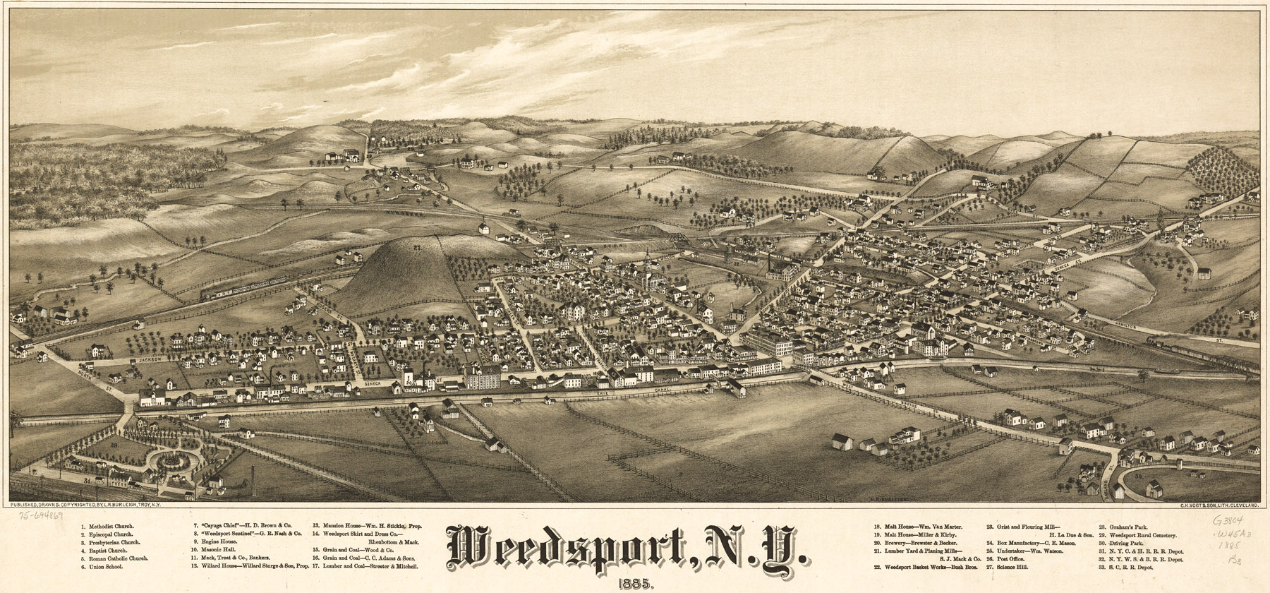
1885
Weedsport NY Panoramic Map (Courtesy of Bernie
Corcoran)
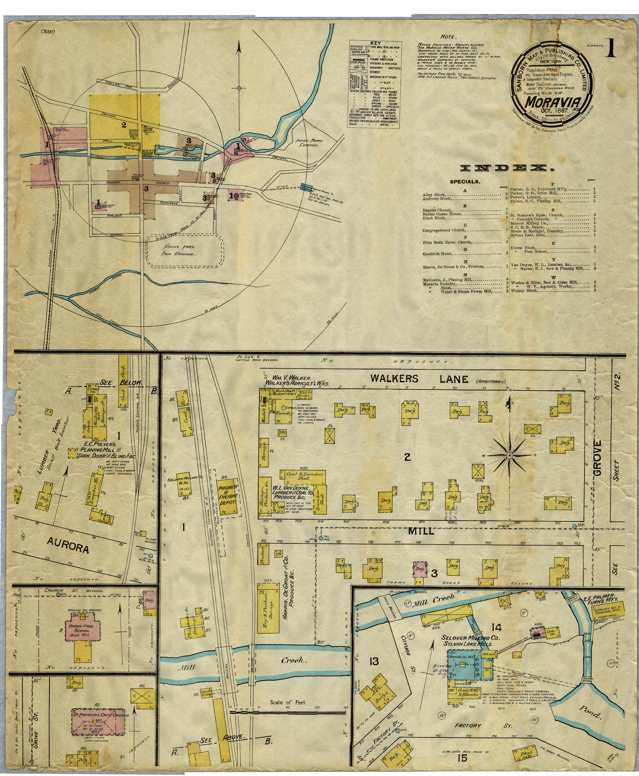
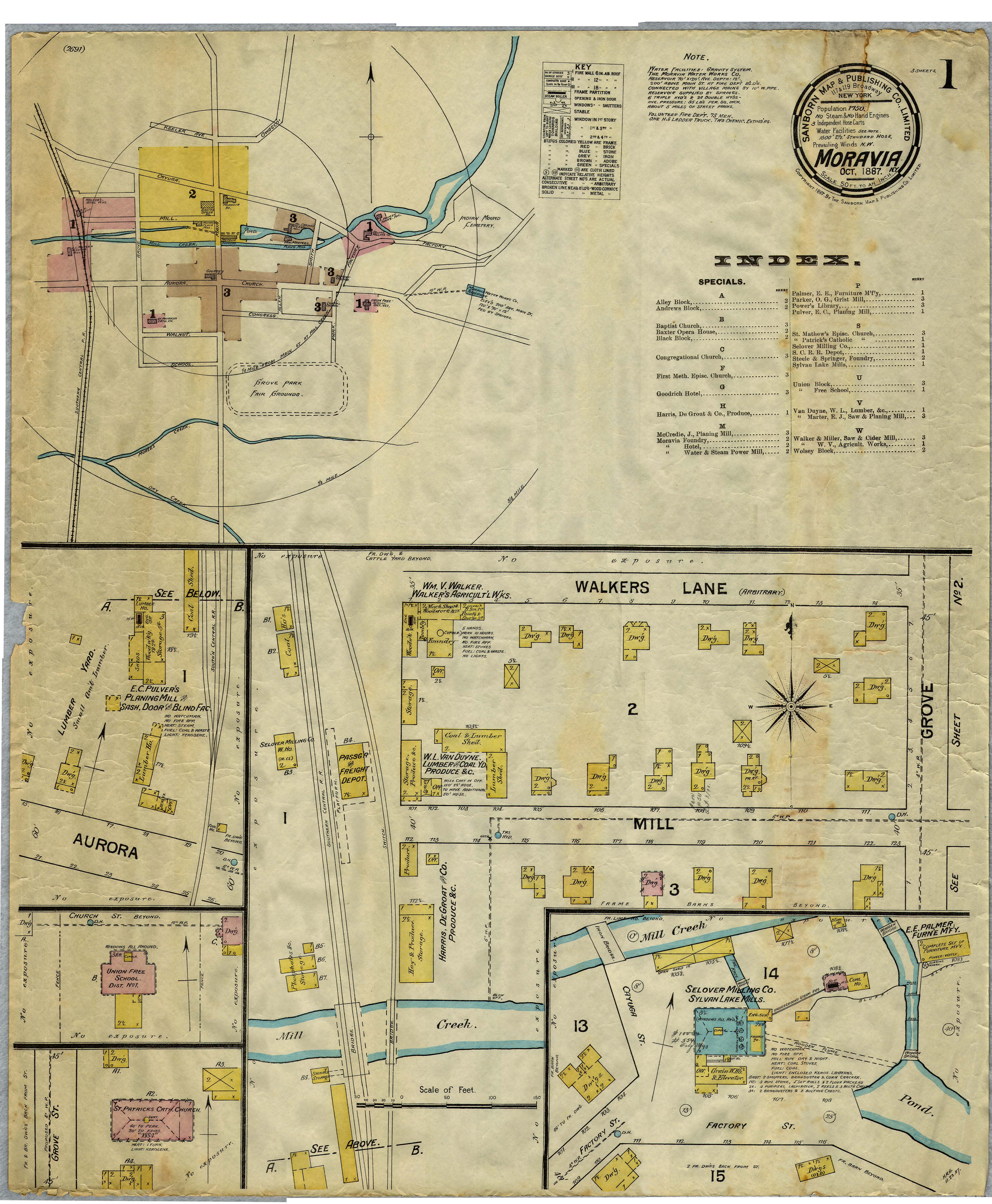
1887
Moravia NY Map Sanborn Fire Ins. Map
(Larger)
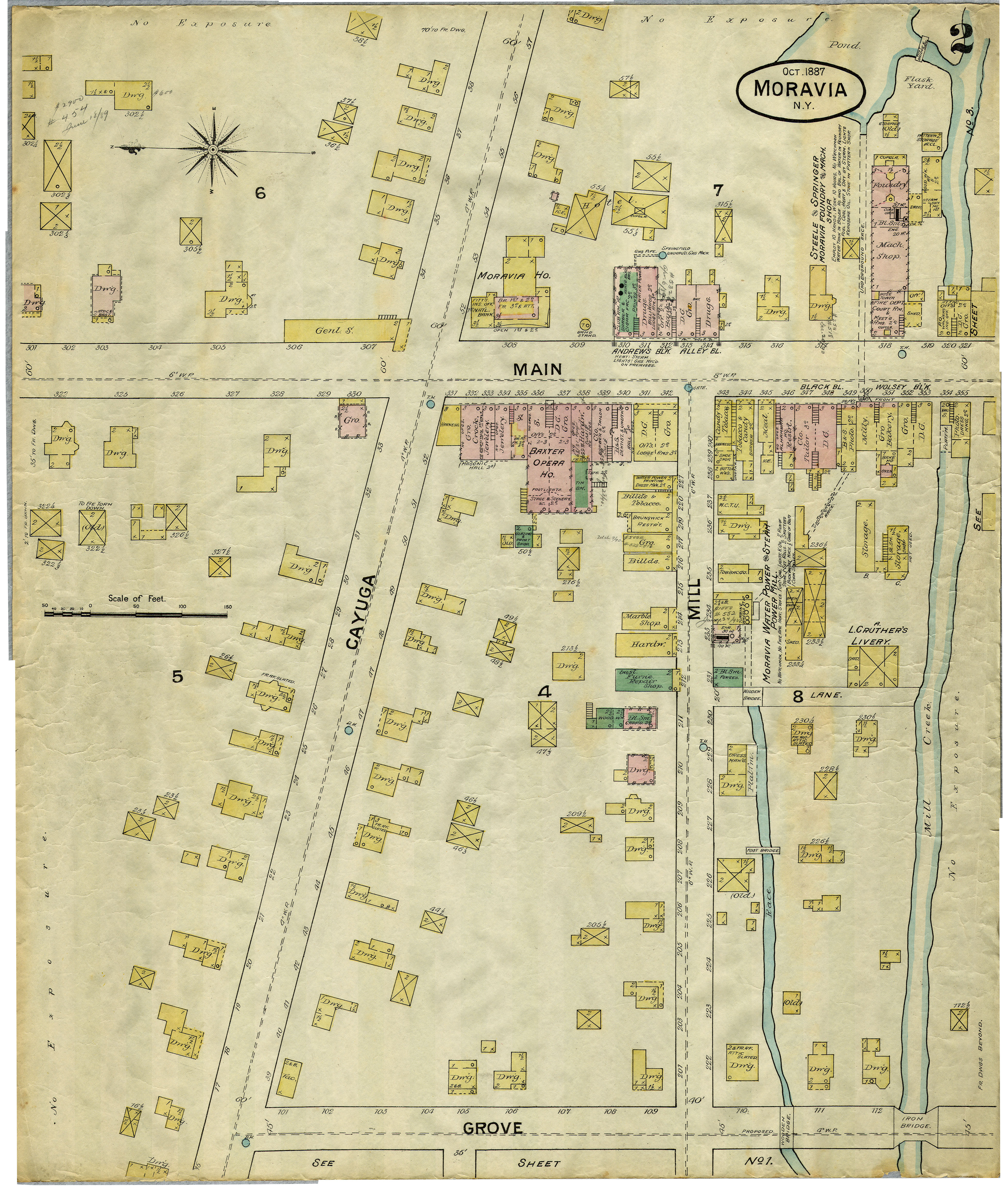
Pg.2
(Pg.2
Larger)
1887
Union Springs NY Sanborn Fire Insurance Map, Image1, Image 2, Image 3
Circa 1890s Cayuga Lake
Map-Steamboat Flyer (Courtesy of Bill Hecht)
1892
Sanborne Map Of Auburn NY - Map #6 - Auburn Wollen Mill and Owasco
Outlet
(Larger
View) (Courtesy of Bill Hecht)
1892
Sanborne Map Of Auburn NY - Map #7 - South St, Logan, Lincoln and Grover
St. (Courtesy of Bill Hecht)
1892
Sanborne Map Of Auburn NY - Map #8 - D.M. Osborne (Current
Wegman's)
(Larger
View) (Courtesy of Bill Hecht)
1892
Sanborne Map Of Auburn NY - Map #11 - North, Water and State
streets and Owasco Outlet
(Larger
View) (Courtesy of Bill Hecht)
1892
Sanborne Map Of Auburn NY - Map #12 - Water, North, South, and Genesee
St. (Larger
View) (Courtesy of Bill Hecht)
1892
Sanborne Map Of Auburn NY - Map #14 - Birdsall Plant, Armory, McMaster
and Owasco Outlet
(Larger
View) (Courtesy of Bill Hecht)
1892
Sanborne Map Of Auburn NY - Map #18 - Dunn and McCarthy and Owasco
Outlet (Larger
View) (Courtesy of Bill Hecht)
1892
Sanborne Map Of Auburn NY - Map #22 - Auburn Wollen Mill, and Wadsworth
Street
(Larger
View) (Courtesy of Bill Hecht)
1892
Sanborne Map Of Auburn NY - Map #23 -
Nye-Wait (Larger
View #1
#2)
(Courtesy of Bill Hecht)
1892
Sanborne Map Of Auburn NY - Map Area With Auburn Prison
(Larger
View) (Courtesy of Bill Hecht)
1893 Sanborne Fire Insurance Maps of Union Springs NY Image 1, Image 2, Image 3
1894
Map Showing Auburn Woolen Co. Property In Auburn -
Larger
View (Courtesy of Bill Hecht)
1899 Morgan Map Of NY State - Larger View (Courtesy of Bill Hecht)
Early Auburn NY Map With Historical References To Settlement - Alternate Image (Courtesy of Bill Hecht)
HistoryForge combines historic maps and photos with census records of the people who lived in Auburn, NY, creating a unique way to visualize the history of this community in the early 1900s. See
https://auburn.historyforge.net/
1900 County Map - Foster Ross &
Baucus
1902
Map Of E.D. Clapp Mfg. Co. In Auburn NY
(Larger
View) (Courtesy of Bill Hecht)
1902 Map Showing Auburn NY Trolley Routes (Courtesy of Deborah Martin-Plugh)
1903 Owasco Lake Chart Small (Larger Image)
1904 New Century Atlas Of Cayuga County
NY (Courtesy of Bill Hecht)
1904 Auburn NY Sanborn Insurance Maps (Some maps may be updated to the 1920s) (Courtesy
of Don Laxton Est. and Bill Hecht)
1905
Geological Map Of Union Springs & Vicinity (Courtesy
of Bill Hecht)
1906
Union Springs NY Sanborn Fire Insurance Map
1908 Watershed
Map Of Central NY (Courtesy of Bill Hecht)
1908 Watershed
Map Of Eastern NY (Courtesy of Bill Hecht)
1909
USGS Map Chart Of Cayuga Lake (Courtesy of Bill
Hecht)
1909-1910
Auburn NY Map -
Large
Version (Courtesy of Bill Hecht)
1911
Cayuga County Map -
Large
Version (Courtesy of Bill Hecht)
1912 Map showing contours / topography for Owasco Lake area
- Larger View (Courtesy of Bill Hecht)
1913 Map of LVRR Routes (Courtesy
of Bill Hecht)
(Some 1914 Maps for NY Sate Areas can be found on Janie Edwards
website at:
http://freepages.genealogy.rootsweb.ancestry.com/~shastaca/maps/NY/NYmapsindex.html
)
1915 Cayuga County
NY Road
Map
1916 Auburn NY Engineering Dept. Street Report-PDF File (Courtesy of Bernie Corcoran)
Early Map of The Seneca River near the Cayuga-Seneca Canal (From
the NYS Archive-Courtesy of Bill Hecht)
Early Map of the Cayuga Canal at Aurelius (From
the NYS Archive-Courtesy of Bill Hecht)
1918 Rochester & Syracuse Electric Railroad Detail Map (Redrawn in 1960) - 1916 RR Freight Service Timetable
1922 Cayuga County NY Soil
Map (Courtesy of Bill Hecht)
1926
Cayuga County NY Rural Directory Map
(Larger
View)-Northern
Cayuga County
(Larger
View)
Name
List (Courtesy of Bill Hecht)
1931 NY Road Map (Small Image)-
Medium Size Image-
Large Image (Courtesy of Bill Hecht)
1936 SOCONY Road Map Of The Finger Lakes (Courtesy of Bill
Hecht)
1936-37 Cayuga Co. Rural Directory & Map Images (Courtesy of Bill
Hecht)
Howland Island 1938, 1871, 1954 (Courtesy of Bill Hecht)
1947
Four Settlements Made A City Map Of Auburn NY -
(Larger
View) (Courtesy of Bill Hecht)
Circa 1947- Auburn NY Air Photo (Larger View) &
Circa 1947 Auburn NY Map (Medium View) (Larger View) (Courtesy of Bill Hecht)
Circa
1955 Map - Auburn Area - Cover Page (Auburn
Area Map -
Larger
View) (Courtesy of Bill Hecht)
Circa
1955 Map - Cayuga to Skaneateles Section -
Larger
View (Courtesy of Bill Hecht)
Circa
1955 Map - Skaneateles Area -
(Larger
View) (Courtesy of Bill Hecht)
Circa Late 1950s Auburn NY Map With Business Ads 96dpi- Larger 400dpi (17.4MB) (Courtesy of Bernie Corcoran)
Early
Railroad Map Of Western New York
(Larger
View) (Courtesy of Bill Hecht)
Map
Of Land s Of The Cayugas
(Medium
Size Image)
(Large
Image)
Cayuga County Postal Route Map Links- Legend; Port Byron & Montezuma Area; Cayuga, Levanna, Union Springs Area; Aurora- Poplar Ridge & King Ferry Area; Venice Center, Moravia, Genoa Area; Weedsport Sennett Area; Owasco, Fleming, Ensenore Area; Cato, Meridian Area; New Hope Area; Montville, Sempronius Area; Fair Haven, Sterling Area; Victory, Ira Area (Courtesy of Bill Hecht)
1974 NOAA Depth And Navigation Chart Map Of Cayuga Lake (Courtesy of Bill Hecht)
Deed Research & Deed Description Plots For Original Brutus Township Lot #3 (Now Conquest NY) (Courtesy of Bernie Corcoran)
Deed Research with Deed Plots related to Worden Babcock & Babcock Family Cemetery in Scipio NY (Courtesy of Bernie Corcoran)
Deed Research With Deed Plots Related To Joseph Gunsaulus - Original Sempronius Township Lots 16 & 17- Now Niles NY (Courtesy of Bernie Corcoran)
Deed Research and Plots Related To Peter or George Ransier- Original Brutus Township Lot 59- Later Mentz & Montezuma NY (Courtesy of Bernie Corcoran)
The HistoryForge Website includes links to some Geo-Rectified Maps of Cayuga County NY and can be viewed at: https://auburn.historyforge.net/forge
http://docs.unh.edu/nhtopos/nhtopos.htm
with permission from The David Rumsey Collection
Morse 1794 Map
Reid 1796 Map
1804 DeWitt Map
Cayuga County NY Portion Of Eddy 1818 Map
Cayuga County NY Portion Of Lucas 1823 Map
Cayuga County NY Portion Of Tanner 1823 Map
Cayuga County Portion- Vance 1825 Map Section 1, Section 2, Section 3, Section 4,
1835 Burr Map
1838 Bradford Map
Cayuga County NY Portion of the 1845 Morse Map
Sanborn Fire Insurance Maps for Cayuga County NY (Library Of Congress Link)
Early map showing Auburn area military tract lots
NEAT old map of Auburn area (Aurelius Lot 55) with important historical info
N end Owasco Lake
Burtis Point?
Dunning Av subdivision
Springside and vicinity
Auburn Theater
Owasco "River-1" - Owasco "River-2" - Owasco "River-3" - Owasco "River-4" - Owasco "River-5" - Owasco "River-6"
Auburn-1, Auburn-2,
WOODLAND BEACH UNION SPRINGS
Cayuga Lakeshore more 50 foot lots
Allens Point map1, Allens Point map2,
Union Spings maps of interest1, Union Springs maps of interest2, Union Spings maps of interest3, Union Spings maps of interest4, Union Spings maps of interest5, Union Spings maps of interest6, Union Spings maps of interest7,
Basin Street area
The Willows
Bertram Hotel site
North Mill Pond
Lakeshore and quarry dock
Village of Cayuga maps
Aurora
Cayuga Lock Postcard
Shows Yawger Brook and Cayuga Junction, old quarries, Richardson Cemetery
Powers Corners, Fred Pethybridge, Yawgers Woods, Cat's Elbow
Union Springs, Powers Corners, Center Street Quarry
Detail of Union Springs
Detail of Aurora
Detail of the Village of Cayuga
Union Springs
Union Springs dock showing Frontenac and McDonalds Point
Ad from Everetts Store in Union Springs, New York.
Austin Brothers blacksmith shop located behind Methodist Church in Union Springs
Courtney home in Union Springs
Paines Creek
Cayuga Junction
Yawgers Creek
Emerson Park
Detail of Emerson Park
Levanna
Great Gulley & Farleys
Hibiscus
Longpoint & Paines Creek
Longpoint; south of Aurora
North Aurora
Wells College
1927 image of Cayuga from frozen lake
1927 view of Cayuga, NY
Infa Red Photo of Cayuga & North Cayuga Lake
Color infa red photos of area east of village of Cayuga
Color infa red photos of Cayuga lake from Aurora to Great Gully
Color infa red photos of Union Springs area from Cayuga Junction south to Farleys Point
Color infa red photos of north east Union Springs area
Union Springs AirPhoto
1938 Airphoto of Paynes Creek
Frontenac Island Drawing
1838 Map Legend - 1838 Stats - Stats Chart
Text contained on a 1838 Map of Cayuga County
1838 map of Aurelius
1838 Map of Canal Towns
1838 Map of Genoa
1838 Map of Town of Ira
1838 map of Ledyard
1838 map of Moravia and Lock
1838 Niles Map
1838 Scipio Map
1838 Springport map
1838 Map of Town of Stirling
1838 Map of Northern Cayuga County towns of Stirling, Vitory, and Ira
1838 Map of Venice
1838 Map of Town of Victory
Geological Map Of Union Springs
Print of Cayuga Lake
Cayuga Bridge